Carbon markets run on one thing above everything else:
Trust.
When a carbon project claims that it has:
- reduced emissions,
- removed carbon,
- restored ecosystems,
- or improved climate outcomes,
those claims must be measurable and verifiable.
This is why Monitoring, Reporting, and Verification (MRV) sits at the center of every credible carbon project.
But as climate projects scale across larger geographies and involve more stakeholders, traditional MRV systems are increasingly struggling to keep pace.
Manual workflows, fragmented field records, delayed reporting, and weak data traceability are becoming major operational risks.
That is why the climate industry is rapidly moving toward Digital MRV (dMRV).
Today, digital monitoring systems are no longer viewed as optional innovation layers.
They are becoming core infrastructure for scalable and high-integrity climate projects.
In this blog, we will explore:
- what MRV means,
- what digital MRV means,
- the key differences between MRV and dMRV,
- why the industry is shifting toward digital systems,
- the limitations of technology-only approaches,
- and how integrated field-tech models are changing climate implementation.
What is MRV?
MRV stands for:
- Monitoring
- Reporting
- Verification
It is the framework used to track and validate climate impact in carbon projects.
MRV systems help answer questions like:
- Were project activities actually completed?
- Did the plantations survive?
- Was the land eligible?
- Were emissions reduced?
- Is the field evidence reliable?
- Does the project comply with registry standards?
Without MRV, carbon credits cannot maintain credibility.
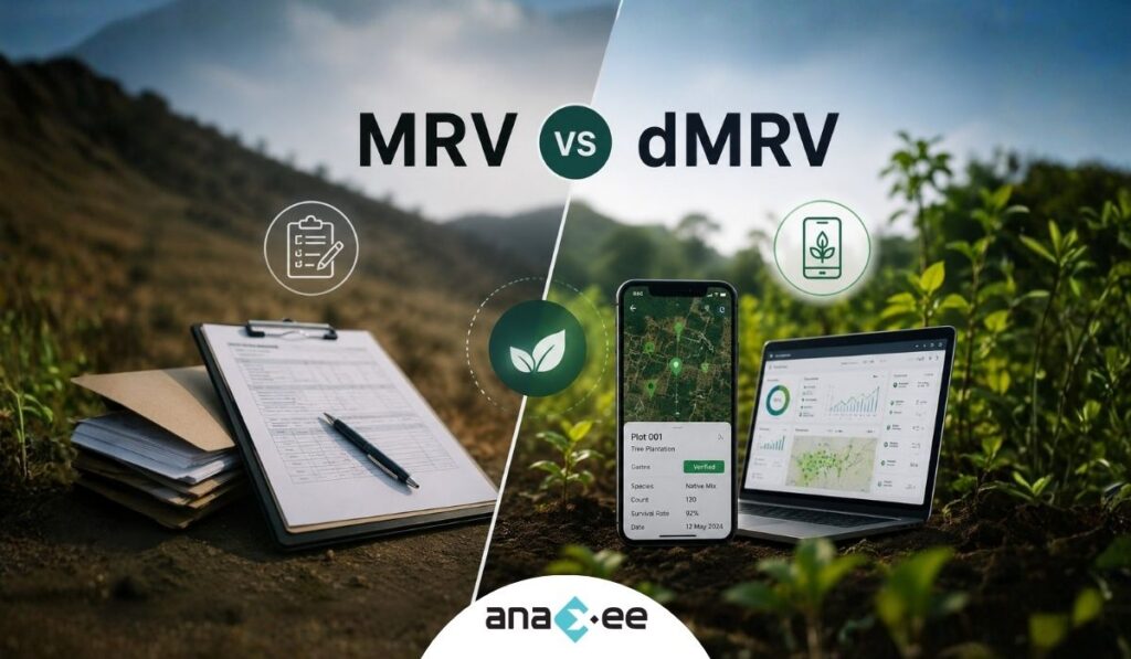
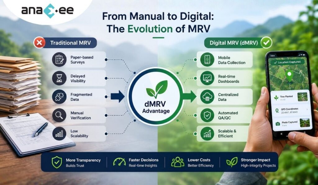
What is Traditional MRV?
Traditional MRV refers to monitoring systems that rely heavily on:
- manual surveys,
- paper forms,
- spreadsheets,
- disconnected reporting systems,
- physical verification,
- and delayed audits.
Many carbon projects globally still operate through partially manual MRV workflows.
This approach may work for smaller projects, but as projects expand across:
- multiple villages,
- thousands of farmers,
- and distributed field teams,
manual systems become increasingly difficult to manage efficiently.
What is Digital MRV (dMRV)?
Digital MRV, often called dMRV, uses technology to improve Monitoring, Reporting, and Verification processes.
Instead of depending mainly on manual documentation, dMRV combines:
- mobile-based field data collection,
- geo-tagging,
- satellite monitoring,
- digital evidence capture,
- dashboards,
- cloud databases,
- QA/QC workflows,
- and AI-assisted analytics.
The goal is not just digitization.
The goal is:
- better transparency,
- stronger traceability,
- faster reporting,
- improved scalability,
- and more reliable monitoring systems.
MRV vs dMRV: The Core Difference
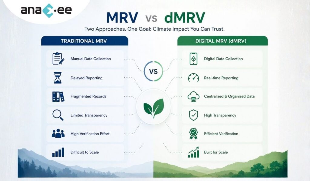
At a basic level:
Traditional MRV depends largely on manual processes.
Digital MRV strengthens monitoring through technology-enabled systems.
However, the actual difference goes much deeper.
MRV vs dMRV Comparison Table
| Area | Traditional MRV | Digital MRV (dMRV) |
|---|---|---|
| Data Collection | Paper forms and spreadsheets | Mobile applications and digital workflows |
| Reporting Speed | Slow and delayed | Faster and near real-time |
| Geo-Verification | Limited | GPS-enabled and geo-tagged |
| Evidence Collection | Manual photos and documents | Digital evidence with metadata |
| Transparency | Difficult to track | Stronger traceability |
| QA/QC | Manual review | Automated validation support |
| Scalability | Difficult at large scale | Designed for scale |
| Audit Readiness | Fragmented records | Centralized digital records |
| Field Visibility | Limited | Dashboard-based monitoring |
| Operational Efficiency | Lower | Higher |
Why Traditional MRV Systems Struggle Today
Carbon projects are becoming more operationally complex.
A single project may involve:
- thousands of farmers,
- hundreds of villages,
- multiple field agencies,
- seasonal monitoring cycles,
- remote geographies,
- and multiple reporting requirements.
Traditional MRV systems often struggle under this complexity.
1. Delayed Data Flows
Field data may take weeks to reach project managers.
By the time issues are identified:
- plantations may fail,
- surveys may become outdated,
- or reporting windows may close.
2. Weak Traceability
In fragmented systems, it becomes difficult to verify:
- who collected the data,
- where the data originated,
- whether the field visit actually happened,
- and whether evidence is authentic.
3. Scaling Problems
Manual monitoring may work across:
- 10 villages.
But it becomes difficult across:
- 5,000 villages.
Scale changes everything operationally.
4. High Verification Burden
Auditors often spend significant time organizing fragmented records before verification can even begin.
This increases:
- costs,
- delays,
- and operational friction.
Why the Industry is Moving Toward dMRV
The climate sector is under increasing scrutiny.
Carbon buyers, investors, registries, and regulators now expect:
- stronger transparency,
- implementation evidence,
- better reporting systems,
- and higher data integrity.
Digital MRV helps improve all of these areas.
How Digital MRV Improves Carbon Project Monitoring
Mobile-Based Field Data Collection
Field teams can use mobile applications to:
- collect surveys,
- capture geo-tagged photos,
- record coordinates,
- upload field evidence,
- and sync records centrally.
This reduces dependency on manual paperwork.
Geo-Tagging and Timestamping
Digital systems can link every activity with:
- GPS coordinates,
- timestamps,
- user identity,
- and device information.
This improves accountability and traceability.
Centralized Dashboards
Dashboards allow project managers to monitor:
- village coverage,
- plantation progress,
- survey completion,
- survival rates,
- field activity,
- and operational bottlenecks.
This improves project visibility significantly.
QA/QC Workflows
Modern dMRV systems can support:
- duplicate detection,
- anomaly identification,
- evidence verification,
- random audits,
- and validation workflows.
This strengthens data quality management.
Remote Monitoring and Satellite Integration
Satellite monitoring and remote sensing can help monitor:
- land-use changes,
- forest cover,
- vegetation growth,
- and project boundaries.
However, satellite systems still require ground validation for many project activities.
A Common Misconception About dMRV
Many people assume:
Digital MRV means everything becomes automated.
That is not true.
Technology improves systems.
But it cannot fully replace field execution.
A mobile app cannot build community trust.
A dashboard cannot engage farmers.
Satellite imagery cannot validate every ground reality.
Strong climate implementation still depends heavily on:
- field coordination,
- local engagement,
- physical verification,
- and disciplined operations.
Why Ground Execution Still Matters
This becomes especially important in:
- agroforestry projects,
- community-led climate initiatives,
- rural sustainability programs,
- and CSR implementation.
Projects operating in rural India often face:
- connectivity limitations,
- fragmented landholdings,
- language diversity,
- logistical challenges,
- and inconsistent field conditions.
Technology alone cannot solve these realities.
The strongest monitoring systems combine:
- digital infrastructure,
- and strong last-mile execution.
The Rise of Hybrid Climate Monitoring Systems
The future of climate monitoring is likely hybrid.
Meaning:
- technology-enabled systems,
- supported by reliable ground operations.
This includes:
- mobile-first workflows,
- geo-tagged evidence,
- distributed field teams,
- satellite integration,
- QA/QC systems,
- centralized dashboards,
- and audit-ready reporting.
Organizations that can integrate these layers effectively may have a major operational advantage.
How Anaxee’s Tech for Climate Approach Fits Into This Shift
One of the biggest gaps in climate implementation today is the disconnect between:
- software systems,
- and field execution.
Many organizations build dashboards.
Many organizations collect data.
But very few integrate:
- technology,
- field operations,
- local execution networks,
- and monitoring workflows together.
This is where Anaxee’s Tech for Climate approach becomes relevant.
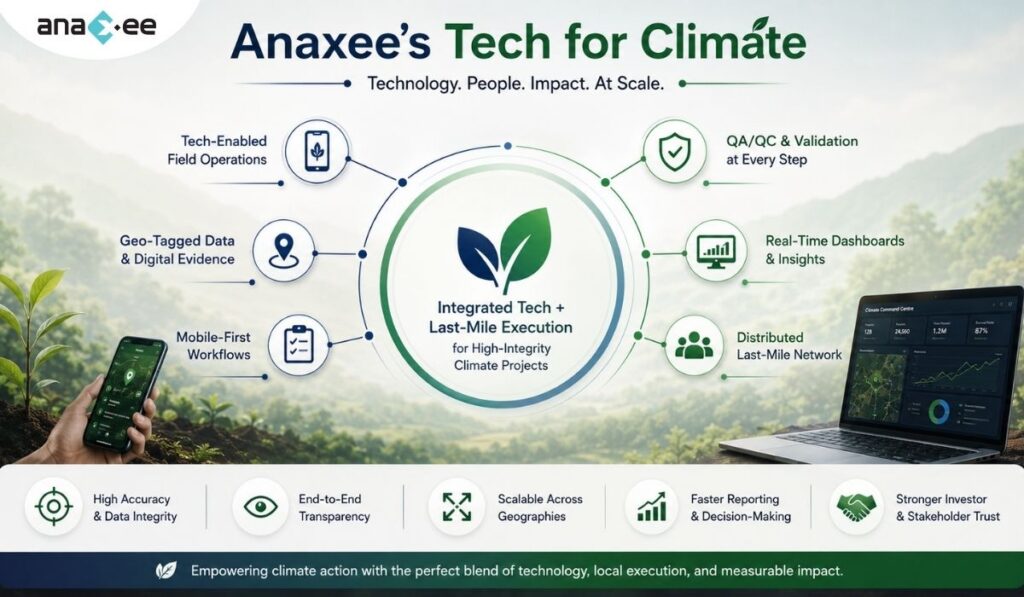
The model combines:
- tech-enabled field operations,
- geo-tagged monitoring,
- digital evidence collection,
- mobile-based workflows,
- QA/QC systems,
- and distributed last-mile execution capabilities.
This becomes particularly useful in projects involving:
- agroforestry,
- plantation monitoring,
- CSR implementation,
- rural sustainability initiatives,
- and community-based climate programs.
Why Last-Mile Networks Matter in dMRV
Digital systems are only as effective as the quality of field execution supporting them.
For example:
- a plantation app still needs real plantations,
- a geo-tagged survey still needs actual field visits,
- and dashboards still depend on reliable field data.
This is why distributed local execution networks are increasingly important in climate implementation.
Anaxee’s Digital Runner network model is designed to help bridge this operational gap between:
- centralized monitoring systems,
- and decentralized field realities.
This improves:
- field coordination,
- operational visibility,
- implementation scalability,
- and evidence collection.
The Future of MRV is Moving Toward Transparency
The climate sector is clearly moving toward:
- stronger accountability,
- better implementation evidence,
- higher monitoring standards,
- and more transparent reporting systems.
As this transition accelerates, projects with weak monitoring systems may face:
- investor scrutiny,
- operational inefficiencies,
- and credibility challenges.
High-integrity monitoring is increasingly becoming a competitive advantage.
FAQs on MRV vs dMRV
What is MRV in carbon projects?
MRV stands for Monitoring, Reporting, and Verification. It is used to validate climate impact in carbon projects.
What is digital MRV?
Digital MRV (dMRV) uses technology such as mobile apps, geo-tagging, dashboards, and satellite monitoring to improve carbon project monitoring.
What is the difference between MRV and dMRV?
Traditional MRV relies heavily on manual systems, while dMRV uses digital tools to improve transparency, scalability, and reporting efficiency.
Why is digital MRV becoming important?
Carbon projects are scaling rapidly, making manual monitoring systems increasingly difficult to manage efficiently.
Can digital MRV replace field verification?
No. Technology improves monitoring, but field validation and ground execution remain essential.
What technologies are used in dMRV?
Common technologies include:
- mobile applications,
- geo-tagging,
- dashboards,
- cloud databases,
- satellite monitoring,
- AI-assisted analytics,
- and QA/QC systems.
Why are geo-tagged surveys important?
Geo-tagged surveys improve traceability and help validate field activities.
What role do dashboards play in climate projects?
Dashboards improve operational visibility, reporting efficiency, and project transparency.
Final Thoughts
The shift from traditional MRV to digital MRV is not just a technology trend.
It reflects a deeper industry need for:
- transparency,
- scalability,
- traceability,
- and operational credibility.
As carbon markets mature, monitoring systems will likely become one of the most important indicators of project integrity.
But technology alone is not the answer.
The strongest climate implementation models combine:
- digital systems,
- local field execution,
- operational discipline,
- and transparent workflows.
This intersection between:
- technology,
- monitoring,
- and last-mile implementation
is where the future of scalable climate projects is increasingly being built.
Looking to strengthen monitoring, transparency, and field execution in climate or CSR projects?
Explore how Anaxee’s Tech for Climate approach combines digital MRV systems, geo-tagged field operations, QA/QC workflows, dashboards, and distributed last-mile execution networks to support scalable climate implementation across India.