


Bund (boundary) plantations are a farmer-friendly form of agroforestry in India: rows of trees planted along field edges while the core land continues to grow food crops. Under Verra’s VM0047 Afforestation, Reforestation & Revegetation (ARR) methodology, these living fences can generate high-integrity carbon credits- if they follow the census-based approach.
Thank you for reading this post, don't forget to subscribe!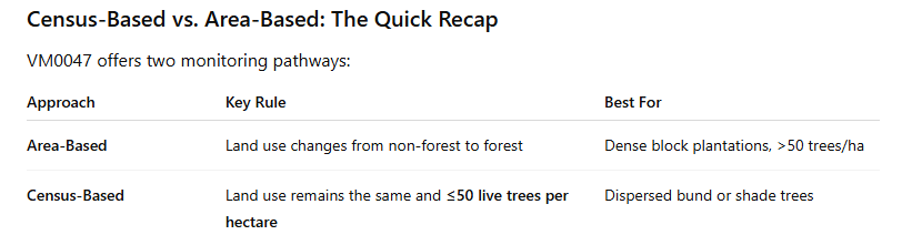
Why Choose the Census-Based Route?
- No land-use change- Cropping continues, so farmers keep their primary income.
- Lower data burden than area-based- You tag and track individual trees, not sample forest plots.
- Ideal for smallholders- Average Indian farm size ≈ 1 ha; a census lets you aggregate thousands of tiny parcels into one program.
Practical Tips to Stay Within 50 Trees per Hectare
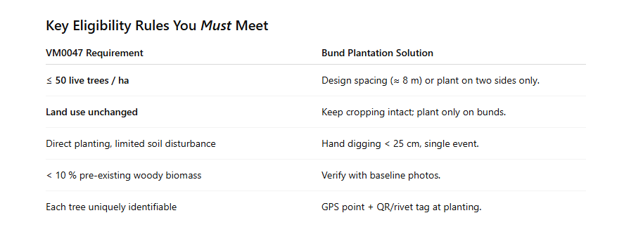
- Measure the perimeter first. A 1-ha square plot is ~400 m around; planting every 8 m gives 50 trees.
- Prioritize corners & windward sides for shade/wind-break benefits.
- Rotate species- fast-growing nitrogen fixers (Gliricidia, Sesbania) plus high-value timber (Teak, Melia).
Monitoring & Tagging SOPs
- Planting Day: Assign a numeric ID, fix a weather-proof tag, record GPS coordinates in a mobile app.
- Year 1 & 3 Survival Check: Quick visual count; remove dead IDs from the live database (no replacement beyond 50/ha).
- Year 5 Growth Sample: Random 10 % of trees- measure DBH and height for biomass equations.
- Photographic Evidence: At each visit, 3 geotagged photos (tag close-up, full tree, farm context).
Carbon Accounting Snapshot
- Live Tree Count × Average Biomass Growth → Annual CO₂ removal.
- Leakage: Negligible, since cropping is intact.
- Buffer Deduction: Apply Verra’s risk tool (fire, pests).
Benefits Beyond Carbon
- Wind-break & soil-moisture retention→ higher crop yields.
- Diversified farm income from timber or fruit.
- Biodiversity corridors connecting fragmented habitats.
Key Takeaways
- Bund agroforestry does qualify under VM0047’s census-based pathway- but only when you cap density at ≤ 50 trees per hectare and tag every tree.
- Robust DMRV (Digital Monitoring, Reporting & Verification)- QR tags, GPS, periodic growth sampling- keeps auditors satisfied and credits flowing.
- For smallholder aggregators like Anaxee, this model scales easily across thousands of farms, delivering verified carbon credits plus real rural co-benefits.
We hope you found this information helpful. For any further details or collaboration opportunities, feel free to reach out to us at sales@anaxee-wp-aug25-wordpress.dock.anaxee.com.
 About Anaxee
- ★ National Startup Award 2021
- Trusted by 350+ brands
- India’s Reach Engine since 2016
Explore Anaxee: Go-To-Market · Field data collection · Platform & API · Drone & MRV · Climate
Planning field execution, a GTM rollout or data collection across India?
Tell Anaxee the outcome and the geography — our team will map it across 540 districts and 11,000+ pincodes.
Book a meeting WhatsApp Email sales

