The carbon market is expanding rapidly.
Corporates are investing in net-zero commitments. Climate funds are scaling nature-based solutions. Governments are introducing carbon market frameworks. Carbon project developers are working across forestry, agroforestry, soil carbon, renewable energy, and community-based climate initiatives.
But beneath the growth, one operational reality continues to create serious problems across the industry:
Monitoring climate projects at scale is extremely difficult.
Many carbon projects are spread across:
- remote villages
- fragmented landholdings
- multiple implementation partners
- thousands of farmers
- large field teams
- difficult terrains
As projects scale, monitoring becomes one of the biggest operational and credibility challenges in the climate ecosystem.
And today, credibility matters more than ever.
Investors, registries, auditors, and carbon credit buyers increasingly want:
- transparent implementation
- reliable field data
- traceable evidence
- audit-ready systems
- high-integrity monitoring workflows
This is where digital MRV and climate technology are becoming critical.
In this article, we will explore:
- the biggest carbon project monitoring challenges
- why traditional systems struggle
- how technology is solving these problems
- why ground execution still matters
- how integrated field-tech models are reshaping climate project implementation
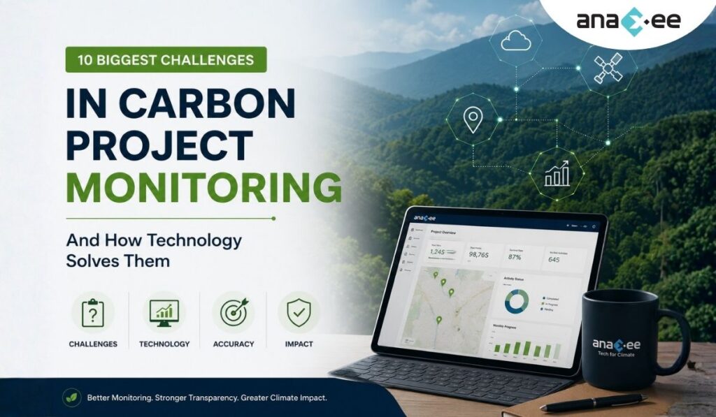
Why Carbon Project Monitoring is So Important
Carbon credits are only as credible as the systems used to monitor them.
Every carbon project depends on field evidence to answer questions like:
- Were plantations actually completed?
- Did trees survive?
- Was the land eligible?
- Were farmers properly onboarded?
- Were project activities implemented correctly?
- Is the reported impact real?
Weak monitoring systems can create:
- inaccurate carbon claims
- audit failures
- investor distrust
- reporting delays
- operational inefficiencies
This is one reason why the climate sector is increasingly focused on stronger Monitoring, Reporting, and Verification (MRV) systems.
The Shift Toward Digital MRV
Traditional monitoring approaches often depend on:
- paper-based surveys
- Excel sheets
- disconnected field agencies
- delayed reporting
- manual validations
These systems become difficult to manage at scale.
Digital MRV (dMRV) helps improve monitoring through:
- mobile-based field data collection
- geo-tagging
- digital evidence collection
- dashboards
- QA/QC systems
- satellite monitoring
- audit trails
- centralized workflows
But technology alone is not enough.
Strong implementation still requires disciplined field operations and reliable ground execution.
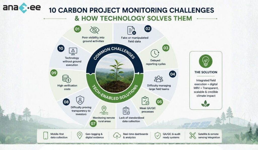
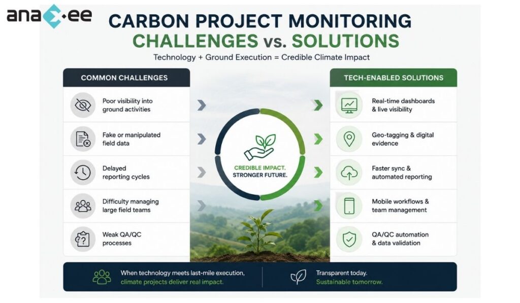
1. Poor Visibility into Ground-Level Activities
One of the biggest challenges in carbon projects is limited visibility into actual field implementation.
Senior project teams often struggle to answer:
- Which villages have been covered?
- Which farmers were visited?
- Are plantations actually happening?
- Are survival surveys being completed?
- Is the field data genuine?
In traditional systems, updates may arrive days or weeks later.
This creates operational blind spots.
How Technology Helps
Digital monitoring systems improve visibility through:
- live dashboards
- real-time survey tracking
- geo-tagged updates
- timestamped field records
- centralized reporting
Project teams can monitor implementation progress much more efficiently.
2. Fake or Manipulated Field Data
Data integrity is a major issue in climate projects.
Common problems include:
- duplicate surveys
- fake geo-tagging
- reused photographs
- fabricated farmer records
- incomplete field visits
When projects scale rapidly, these risks increase significantly.
How Technology Helps
Modern dMRV systems can improve traceability using:
- GPS validation
- timestamp verification
- user-level tracking
- digital audit trails
- image metadata checks
- QA/QC workflows
This improves accountability across field operations.
3. Delayed Reporting Cycles
Many projects still depend on manual data compilation.
This slows down:
- project reporting
- investor updates
- verification workflows
- issue resolution
By the time project teams identify operational problems, the field season may already be over.
How Technology Helps
Digital workflows allow:
- faster synchronization
- centralized databases
- automated reporting
- live monitoring dashboards
This reduces reporting delays significantly.
4. Difficulty Managing Large Field Teams
Carbon projects often involve:
- local surveyors
- implementation agencies
- NGOs
- community mobilizers
- plantation teams
- monitoring staff
Managing distributed field teams across multiple states is operationally complex.
How Technology Helps
Technology platforms help coordinate field operations through:
- task allocation systems
- mobile workflows
- attendance tracking
- geo-tagged activity logs
- centralized communication
Field-tech integration improves operational consistency.
5. Weak QA/QC Processes
Data collection is only one part of monitoring.
Quality assurance and quality control (QA/QC) are equally important.
Without strong QA/QC:
- errors go unnoticed
- false positives increase
- project risks rise
- verification becomes difficult
How Technology Helps
Digital systems enable:
- automated validation rules
- anomaly detection
- duplicate detection
- supervisor review workflows
- random audits
- evidence verification
This strengthens data quality management.
6. Lack of Standardized Data Collection
In many projects, different teams collect data in different formats.
This creates:
- inconsistent reporting
- missing information
- data compatibility issues
- audit complications
How Technology Helps
Digital forms help standardize:
- survey structures
- field protocols
- evidence formats
- geo-location requirements
- reporting templates
Standardization improves scalability.
7. Monitoring Remote Rural Areas
Many carbon projects operate in:
- forest-edge regions
- tribal belts
- remote villages
- low-connectivity areas
This creates operational challenges for monitoring systems.
How Technology Helps
Offline-first mobile applications allow field teams to:
- collect data without internet
- sync later when connectivity is available
- continue operations in remote regions
This is especially important in India-scale implementation.
8. Difficulty Proving Transparency to Investors
Investors increasingly expect:
- implementation visibility
- traceable workflows
- verifiable evidence
- audit readiness
Simple PDF reports are no longer enough.
How Technology Helps
Digital dashboards and evidence systems improve transparency through:
- geo-tagged images
- live project updates
- centralized evidence repositories
- field activity logs
- progress analytics
This improves investor confidence.
9. High Verification Costs
Verification becomes expensive when:
- records are fragmented
- data is inconsistent
- evidence is missing
- field validation requires excessive manual effort
Large projects can face significant audit costs.
How Technology Helps
Organized digital systems improve verification readiness through:
- structured datasets
- centralized records
- searchable evidence
- digital audit trails
This reduces operational friction during verification.
10. Technology Without Ground Execution
One major misconception in climate tech is that software alone can solve implementation problems.
It cannot.
A dashboard does not plant trees.
An app does not engage communities.
Satellite imagery alone cannot validate every field reality.
Many climate projects fail because they focus only on software while ignoring execution capacity.
What Actually Works
Effective climate implementation requires a combination of:
- field operations
- digital systems
- trained local teams
- QA/QC workflows
- technology-enabled transparency
The strongest projects integrate both technology and ground execution.
Why the Future of Carbon Monitoring is Hybrid
The future of climate monitoring is not fully manual.
And it is not fully automated either.
It is hybrid.
The industry is moving toward systems that combine:
- on-ground field verification
- digital MRV
- satellite monitoring
- remote sensing
- AI-assisted analytics
- centralized operational dashboards
This combination improves:
- scalability
- transparency
- credibility
- operational efficiency
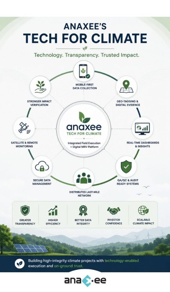
How Anaxee’s Tech for Climate Approach Addresses These Challenges
As climate projects scale across India, one major operational gap continues to emerge:
Many organizations have technology.
Many organizations have project designs.
But very few have reliable last-mile execution systems integrated with digital monitoring.
This is where Anaxee’s Tech for Climate approach is designed differently.
Instead of treating field operations and technology as separate layers, the model integrates:
- tech-enabled field execution
- geo-tagged evidence collection
- mobile-first workflows
- QA/QC systems
- centralized dashboards
- distributed last-mile networks
This becomes especially important in projects involving:
- agroforestry
- plantation monitoring
- CSR implementation
- rural sustainability programs
- community-based climate initiatives
Why Last-Mile Networks Matter in Climate Projects
Climate implementation ultimately happens on the ground.
Whether the project involves:
- tree plantation
- farmer engagement
- survival monitoring
- field surveys
- asset verification
- CSR execution
success depends heavily on local coordination and reliable field operations.
Anaxee’s distributed Digital Runner network model helps bridge the gap between:
- centralized project management
- and decentralized rural implementation
This enables projects to operate across:
- multiple districts
- remote geographies
- large village clusters
- rural and semi-urban regions
with stronger operational visibility.
The Growing Need for High-Integrity Monitoring Systems
The carbon market is moving toward greater scrutiny.
Buyers, registries, and investors increasingly want:
- evidence-backed claims
- transparent implementation
- stronger audit readiness
- reliable monitoring systems
As this shift continues, monitoring quality may become one of the biggest differentiators in climate projects.
Projects that rely only on fragmented manual systems may face increasing operational pressure.
FAQs on Carbon Project Monitoring
What is carbon project monitoring?
Carbon project monitoring refers to the process of tracking, documenting, and validating project activities and climate impact.
Why is monitoring important in carbon projects?
Monitoring helps ensure that carbon claims are accurate, transparent, and verifiable.
What are the biggest monitoring challenges in carbon projects?
Major challenges include:
- poor field visibility
- fake data
- delayed reporting
- weak QA/QC
- fragmented systems
- rural execution complexity
What is digital MRV?
Digital MRV (dMRV) uses technology tools such as mobile apps, geo-tagging, dashboards, and remote sensing to improve Monitoring, Reporting, and Verification.
Can satellite monitoring replace field teams?
No. Satellite monitoring is useful, but strong ground-level execution and field validation remain essential.
What role does geo-tagging play in carbon monitoring?
Geo-tagging helps verify the location and authenticity of field activities.
Why are dashboards important in climate projects?
Dashboards improve operational visibility, reporting efficiency, and project transparency.
What makes a monitoring system audit-ready?
Structured evidence collection, QA/QC workflows, traceable records, and organized reporting systems improve audit readiness.
Final Thoughts
Carbon markets are evolving rapidly.
But as projects scale, monitoring complexity is increasing just as fast.
The future of credible climate implementation will depend heavily on:
- reliable field execution
- transparent monitoring systems
- digital evidence collection
- scalable operational workflows
- integrated technology systems
Digital MRV is becoming a critical part of this transition.
However, technology alone is not enough.
The strongest climate projects combine:
- human networks
- operational discipline
- local implementation capacity
- and technology-enabled transparency
Organizations that can integrate all four effectively will likely play an important role in the future of high-integrity climate projects.
Looking to improve transparency, monitoring, and last-mile execution in carbon or CSR projects?
Explore how Anaxee’s Tech for Climate approach combines digital MRV, geo-tagged field operations, QA/QC workflows, and distributed last-mile implementation systems to support scalable climate projects across India.