What is Digital MRV? A Complete Guide for Carbon Projects in India
Carbon markets are growing rapidly across the world.
Governments, corporations, investors, and climate organizations are investing billions into carbon projects, nature-based solutions, and sustainability initiatives. But one major question continues to shape the credibility of these projects:
How do we verify that the climate impact is actually real?
That is where MRV comes in.
MRV — Monitoring, Reporting, and Verification — is the backbone of carbon projects. Without strong MRV systems, carbon credits lose trust, project outcomes become difficult to validate, and investors struggle to assess real impact.
However, traditional MRV systems are often slow, manual, fragmented, and difficult to scale — especially in countries like India where projects operate across remote geographies, rural communities, and large field networks.
This is why the climate sector is increasingly moving toward Digital MRV (dMRV).
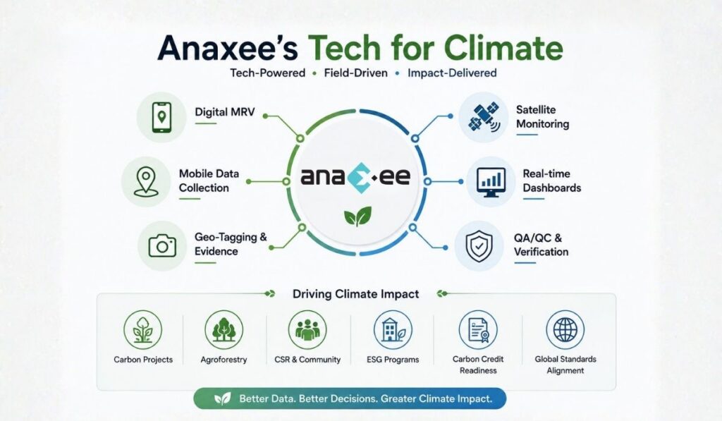
Digital MRV combines field operations, technology, data systems, geo-tagging, satellite monitoring, mobile applications, dashboards, and audit-ready workflows to improve transparency and efficiency in carbon projects.
In this guide, we will explain:
- What MRV means
- What Digital MRV is
- Why it matters in carbon projects
- How dMRV works on the ground
- Technologies used in dMRV
- Challenges in implementing digital monitoring systems
- The future of climate monitoring in India
What is MRV in Carbon Projects?
MRV stands for:
- Monitoring
- Reporting
- Verification
It is the process used to measure, document, and validate climate impact in carbon projects.
MRV helps answer important questions like:
- How many trees survived?
- How much carbon was reduced or removed?
- Was the project implemented correctly?
- Are communities actually participating?
- Is the field data reliable?
- Does the project comply with standards like Verra or Gold Standard?
Without MRV, carbon projects cannot generate credible carbon credits.
Why MRV is Important in Carbon Markets
Carbon markets depend heavily on trust.
If the underlying field data is inaccurate, incomplete, or manipulated, the integrity of the entire carbon credit can be questioned.
This has become a major issue globally.
Several investigations in recent years have raised concerns around:
- poor field validation
- overestimated carbon claims
- weak monitoring systems
- lack of transparency
- inconsistent reporting methodologies
As climate finance grows, investors and buyers are demanding stronger evidence and better traceability.
This is pushing the market toward more technology-enabled monitoring systems.
The Problem with Traditional MRV
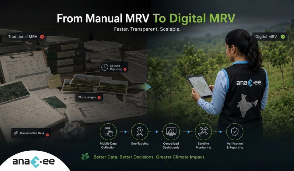
Traditional MRV systems were designed for smaller projects and slower reporting cycles.
In practice, many projects still rely heavily on:
- Excel sheets
- paper surveys
- manual audits
- disconnected databases
- delayed reporting
- third-party field agencies
- scattered photo evidence
- inconsistent geo-tagging
This creates multiple operational problems.
1. Delayed Data Collection
Field data often takes weeks or months to reach project managers.
By the time issues are identified:
- plantations may already fail
- survey errors may become irreversible
- seasonal monitoring windows may close
2. Poor Transparency
Manual systems make it difficult to track:
- who collected the data
- where the data came from
- whether field visits actually happened
- whether photos are genuine
This weakens audit readiness.
3. Scaling Challenges
A carbon project covering:
- 50 villages
- 10,000 farmers
- multiple districts
cannot realistically be monitored through spreadsheets alone.
As projects scale, manual workflows become increasingly inefficient.
4. High Verification Costs
Verification becomes expensive when auditors must manually validate fragmented records across multiple systems.
This increases:
- operational costs
- project delays
- reporting burden
What is Digital MRV (dMRV)?
Digital MRV, also called dMRV, refers to the use of technology to improve Monitoring, Reporting, and Verification processes in carbon and climate projects.
Instead of relying only on manual workflows, digital MRV integrates:
- mobile applications
- geo-tagging
- satellite imagery
- digital evidence collection
- cloud-based reporting
- dashboards
- remote sensing
- AI-assisted analysis
- audit trails
The goal is simple:
Make climate project monitoring more accurate, transparent, scalable, and efficient.
Digital MRV does not completely eliminate fieldwork.
Instead, it strengthens field operations with technology.
How Digital MRV Works
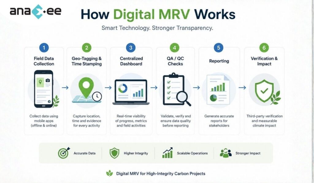
A modern dMRV workflow typically combines multiple layers of data collection and validation.
Step 1: Field Data Collection
Field teams collect data using mobile applications.
This may include:
- plantation details
- farmer enrollment
- tree counts
- GPS coordinates
- geo-tagged photos
- survival status
- land-use information
- socio-economic data
Digital forms help standardize data collection across large geographies.
Step 2: Geo-Tagging and Timestamping
Every field activity can be linked to:
- location coordinates
- timestamps
- user identity
- device information
This improves traceability and reduces fake reporting risks.
Step 3: Centralized Dashboards
Data flows into centralized dashboards where project teams can monitor:
- field progress
- village coverage
- survey completion
- survival rates
- pending validations
- anomalies
This gives real-time operational visibility.
Step 4: QA/QC Workflows
Quality assurance and quality control (QA/QC) processes are critical in dMRV systems.
Project managers can:
- flag suspicious entries
- detect duplicate records
- identify missing coordinates
- verify field images
- conduct random audits
This improves data integrity before verification.
Step 5: Reporting and Verification
Verified data is then used for:
- carbon accounting
- investor reporting
- registry submissions
- audit preparation
- impact reporting
Since the records are digitally organized, verification becomes faster and more transparent.
Technologies Used in Digital MRV
Digital MRV is not a single software product.
It is usually a combination of technologies working together.
Mobile Data Collection Apps
Field teams use mobile applications to:
- collect surveys
- upload photos
- record coordinates
- track field activities
Offline capability becomes important in rural areas with weak connectivity.
Geo-Tagging
Geo-tagging helps validate that field activities happened at the correct locations.
It is widely used for:
- plantations
- asset verification
- CSR activities
- infrastructure monitoring
Satellite Monitoring
Satellite imagery helps monitor:
- land-use change
- vegetation growth
- forest cover
- project boundaries
Remote sensing improves scalability for large projects.
However, satellite monitoring alone is not enough. Ground validation remains essential.
Dashboards and Analytics
Dashboards help project teams:
- monitor implementation
- track KPIs
- identify delays
- analyze field performance
They also improve communication with investors and stakeholders.
AI and Data Intelligence
AI tools are increasingly being used for:
- anomaly detection
- survival prediction
- image validation
- vegetation analysis
- workflow optimization
However, AI still depends heavily on high-quality field data.
Poor input data will still produce poor outcomes.
Why Digital MRV Matters in India
India presents unique operational realities for carbon and climate projects.
Projects often involve:
- dispersed rural geographies
- smallholder farmers
- multiple languages
- difficult terrain
- fragmented landholdings
- limited digital infrastructure
Because of this, implementation quality becomes extremely important.
Digital MRV helps bridge the gap between:
- field execution
- data transparency
- investor confidence
Digital MRV in Agroforestry Projects
Agroforestry projects are among the strongest use cases for dMRV systems.
These projects require continuous tracking of:
- farmer onboarding
- plantation activities
- species details
- survival monitoring
- geo-location
- land ownership
- biomass growth
Managing this manually across thousands of farmers becomes extremely difficult.
Technology-enabled workflows improve consistency and traceability.
Why Ground-Level Execution Still Matters
One misconception is that digital MRV means everything becomes remote or automated.
That is not true.
Technology can improve systems, but climate projects still depend heavily on:
- field teams
- local engagement
- physical verification
- community participation
A dashboard cannot replace real implementation.
This is especially true in:
- rural development projects
- agroforestry programs
- community-led climate initiatives
Strong digital systems only work when supported by strong field execution.
Common Challenges in Digital MRV
Despite its benefits, implementing dMRV systems is not easy.
Connectivity Issues
Many rural regions still face internet limitations.
Offline-first workflows become essential.
Field Training
Technology adoption depends heavily on field team training.
Poor onboarding can create inconsistent data quality.
Device Management
Large field operations require:
- device tracking
- version control
- data synchronization
- app maintenance
Operational discipline matters.
Data Quality Management
Digital systems can still produce bad data if:
- surveys are poorly designed
- teams are rushed
- QA/QC is weak
Technology improves monitoring, but governance remains critical.
The Future of Digital MRV
The carbon market is moving toward:
- real-time monitoring
- AI-assisted validation
- satellite integration
- remote sensing
- blockchain-linked audit trails
- continuous reporting systems
Buyers and investors increasingly expect:
- transparency
- traceability
- implementation evidence
- reliable field data
As climate finance grows, high-integrity monitoring systems will become more important.
Projects with weak operational systems may struggle to maintain credibility.
How Technology is Changing Climate Project Transparency
Digital MRV is ultimately about transparency.
Better monitoring systems help answer important questions:
- Did implementation actually happen?
- Can the project evidence be verified?
- Is the field data trustworthy?
- Are communities genuinely engaged?
- Can investors track progress?
In many ways, dMRV is becoming the operational foundation of modern climate projects.
FAQs on Digital MRV
What does dMRV stand for?
dMRV stands for Digital Monitoring, Reporting, and Verification.
What is the purpose of digital MRV?
Digital MRV helps improve transparency, efficiency, and scalability in carbon and climate projects.
Why is MRV important in carbon projects?
MRV validates whether the climate impact claimed by a project is accurate and verifiable.
What technologies are used in digital MRV?
Common technologies include:
- mobile apps
- geo-tagging
- satellite imagery
- dashboards
- cloud databases
- AI tools
Can satellite monitoring replace field verification?
No. Satellite monitoring is useful, but ground-level validation remains essential for many project activities.
What is the difference between MRV and dMRV?
Traditional MRV relies more on manual workflows, while dMRV uses digital systems and automation to improve monitoring and reporting.
Is digital MRV only used in carbon projects?
No. dMRV systems are also used in:
- CSR projects
- ESG programs
- forestry initiatives
- rural development programs
- sustainability reporting
Why is digital MRV important in India?
India’s climate projects often operate across large rural geographies. Digital MRV improves scalability, transparency, and operational coordination.
Final Thoughts
Carbon markets depend on trust.
And trust depends on reliable monitoring systems.
As climate projects scale across India and globally, traditional monitoring approaches are becoming increasingly difficult to manage.
Digital MRV is helping organizations move toward:
- better transparency
- faster reporting
- stronger verification
- improved operational visibility
- scalable implementation systems
But technology alone is not enough.
Successful climate projects still require:
- strong field execution
- disciplined QA/QC systems
- trained local teams
- reliable data governance
The future of climate monitoring will likely combine:
- digital systems
- remote sensing
- AI-assisted workflows
- and strong on-ground implementation
Projects that can integrate all of these effectively will be better positioned to deliver credible and scalable climate impact.
Looking to build transparent, scalable, and field-ready monitoring systems for carbon or CSR projects?
Explore how technology-enabled field operations, geo-tagging, digital evidence collection, and last-mile implementation workflows are transforming climate project execution in India.