
dMRV vs. Traditional MRV: What Actually Changes on the Ground
“Digital MRV” is one of those terms that means five different things depending on who’s using it.
To a software vendor it means a platform. To a registry it means a specified monitoring approach. To a corporate buyer it usually means “the data is trustworthy, somehow.” And to a field team in rural Madhya Pradesh it means a tablet instead of a paper form — which is real, but not the transformation the word implies.
The confusion has a cost. Developers buy dMRV expecting it to solve verification problems it doesn’t touch, and skip the parts that would have. So it’s worth being concrete about what genuinely changes when monitoring goes digital, and what doesn’t.
The three things people mean by dMRV
They’re different, and they have different price tags.
Digitised collection. Field data captured on an app rather than paper. Forms with validation rules, GPS and timestamp attached at record level, photos embedded, offline sync.
Sensor-based monitoring. Hardware in the field measuring something continuously and reporting it — a temperature sensor on a cookstove, a flow meter, a soil probe. No human in the loop for the measurement itself.
Remote sensing and modelled data. Satellite imagery, model outputs, and geospatial layers used to estimate or verify what’s happening across an area.
Most real projects use some mix. A cookstove project might use digitised KPTs plus sensors on a monitored subset. An agroforestry project might combine plot-level app-based measurement with satellite verification of the plot boundary.
Selling any one of these as “dMRV” without specifying which is where a lot of confusion starts.
What genuinely improves
Four things, and they’re substantial.
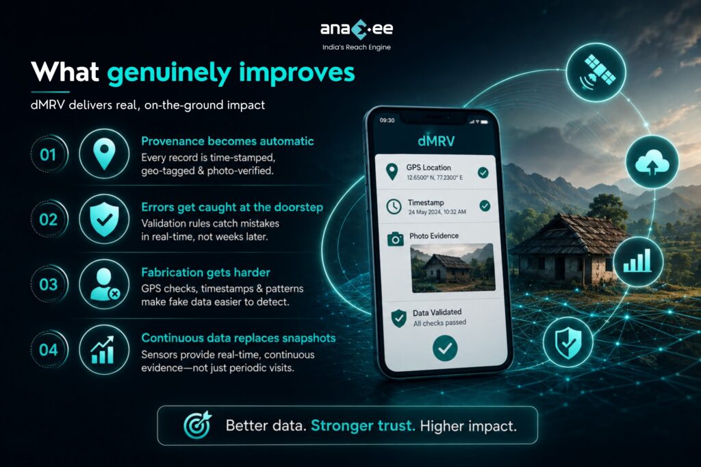
1. Provenance becomes automatic
On paper, proving that a specific enumerator visited a specific household on a specific date requires trusting a signature. Digitally, location and time attach to the record as it’s created. The photograph is embedded, not filed separately.
This is the single largest practical gain, and it’s not about accuracy — it’s about defensibility eighteen months later when a verifier queries a row.
2. Errors get caught at the doorstep
A paper form with an impossible value gets discovered during data entry, weeks later, when returning to the household is expensive. A digital form with validation rules rejects it while the enumerator is still standing there.
That’s the difference between a query and a correction.
3. Fabrication gets harder
Not impossible. Harder.
GPS validation, timestamps, photo requirements and duration checks make casual fabrication detectable. Patterns become visible across a dataset — an enumerator whose surveys all take four minutes, a cluster of records with suspiciously similar responses, submissions from the wrong location.
4. Continuous data replaces snapshots
This is the genuine step change, and it only applies to sensor-based monitoring.
A survey tells you what happened at one moment. A sensor tells you what happened every day. For cookstove usage, where the entire question is whether households are actually using the stove between visits, that difference is the whole argument. Gold Standard’s D-SMART tool exists precisely because the market concluded that periodic snapshots weren’t demonstrating usage well enough.
What doesn’t change
Now the part vendors skip.
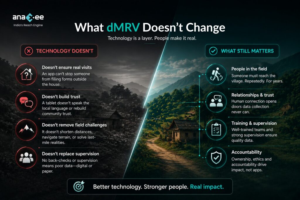
An app doesn’t stop someone sitting outside the house
This is worth saying plainly, because it’s the most common misconception in the category.
If an enumerator stands in the lane and fills a plausible form, GPS shows them at the right location, the timestamp is right, and the photo is of a real stove. The record passes every automated check and is entirely fabricated.
Software catches lazy fabrication. It does not catch competent fabrication. What catches that is back-checks, supervisor spot visits, statistical flagging of response patterns, and enumerators who are trained, paid and supervised properly.
Technology is a layer. It is not a system. A project with a sophisticated app and no back-check protocol has worse data quality than one with paper forms and a rigorous supervision structure.
Sensors have their own failure modes
Devices fall off. Batteries die. Households remove them. Connectivity fails in exactly the remote geographies where projects operate.
Sensor data also needs interpretation. A temperature sensor tells you a stove got hot. It doesn’t tell you a meal was cooked, or how much fuel was used, or whether the traditional chulha was lit an hour later for the second dish. Sensors reduce inference. They don’t eliminate it.
Remote sensing doesn’t see the household
Satellite data is excellent for area, boundary, canopy and change detection. It is weak on anything happening inside a home or below a canopy.
For cookstoves it’s almost irrelevant. For agroforestry it’s powerful for verifying that trees exist where you said, and much weaker on survival, species and management practice. Ground truthing isn’t a legacy step that dMRV replaces — it’s what makes the remote layer meaningful.
The field problem stays a field problem
Someone still has to reach the village. Repeatedly. For years.
A tablet doesn’t shorten the distance to a household in a hilly block in Odisha, doesn’t speak the local language, and doesn’t rebuild trust when the household’s last experience of a carbon project was being sold a stove and hearing nothing since.
Digital tools make good field operations better. They don’t substitute for having one.
What this means for your project design
Five practical positions.
Digitised collection is now table stakes. If you’re still on paper for anything that will face verification, this is the cheapest upgrade available and you should have done it already.
Sensors go where the argument is hardest. Usage and stacking in cookstove projects is the clearest case. Full-population sensor deployment is rarely economic — a monitored subset, correctly sampled, usually does the work.
Budget for the human layer regardless. Whatever you spend on technology, keep back-checks, supervision and training funded. The moment those get cut to pay for the platform, your data quality falls even though your dashboard looks better.
Ask vendors which of the three they actually do. Many “dMRV platforms” are digitised collection with good visualisation. That’s genuinely useful. It’s not sensor-based monitoring, and it shouldn’t be priced as though it were.
Check the methodology, not the marketing. Your registry specifies what monitoring approaches are acceptable and under what conditions. Deploying sensors your methodology doesn’t recognise buys you a nice dataset and no additional credits.
The short version
dMRV makes data traceable, catches errors earlier, makes fabrication harder, and — where sensors are involved — replaces snapshots with continuous evidence. Those are real gains and they matter increasingly, as methodologies converge on direct measurement over estimation.
What it doesn’t do is remove the need for trained people who show up in villages and do careful work under supervision. The projects with the best data aren’t the ones with the most technology. They’re the ones where the technology sits on top of a field operation that was already disciplined.
Buy the layer. Just don’t mistake it for the system.
Anaxee’s Climate Command Centre delivers digital MRV for Indian carbon projects — app-based field collection with record-level GPS and photo capture, sensor-supported usage monitoring, back-check protocols and supervisor verification — through 40,000+ Digital Runners across 540+ districts and 11,000+ pincodes. To discuss the right monitoring mix for your methodology, book a conversation.